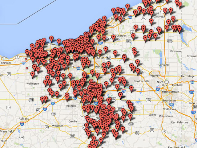
Ohio’s deadliest DUI zone ABC 5 map
CLEVELAND – An exclusive 5 On Your Side investigation analyzed thousands of DUI accidents over ten counties and reveals Northeast Ohio’s deadliest DUI crash zones.
Relying on crash data obtained from the Ohio Department of Public Safety, our investigation mapped every alcohol related crash from 2009 through 2013.
We found 17,454 alcohol related crashes that included 449 deaths and 7,665 injuries throughout Ashtabula, Cuyahoga, Geauga, Lake, Lorain, Medina, Portage, Stark, Summit and Tuscarawas counties.
Our analysis of DUI crash data also revealed hundreds of DUI crash zones: sections of highways where alcohol-related crashes repeatedly occurred.
You can access our exclusive interactive map highlighting fatal, injury and property damage alcohol related crashes.
MAPS
Fatal alcohol-related crashes
Injury alcohol-related crashes
Property damage alcohol-related crashes
In addition, you can access another interactive bar graph that highlights DUI crashes by county—Cuyahoga tops the list with 5,070 alcohol related accidents.


Here is a sample of Northeast Ohio’s deadliest DUI crash zones:
- Cuyahoga County: I-480 between Maple Heights & Cleveland Hopkins Airport. 55 Injuries and 5 fatalities.
- Summit County: I-77 from Ohio Turnpike to just south of Akron. 69 injuries and 9 fatalities.
- Lake County: Route 2 from Eastlake to Painesville. 50 injuries. One fatality.
- Lorain County: Route 6 from Avon Lake to Lorain. 21 injuries. 5 fatalities.
Our investigation also found that even a few miles of road can be deadly.
For example:
- In Cleveland: Union Avenue between 75th and 103rd. 8 DUI related crashes. Half of them fatal.
- In Euclid: Lakeshore Blvd. between 190th and 255th. 18 injuries. 3 fatalities.
- In Medina County: W. Smith Road just west of Medina. 2 fatalities. 6 injuries.
Mothers Against Drunk Drivers says it will use our interactive map as a public safety tool.
“I was like—wow,”, said Julie Leggett, President of the Northeast Ohio Chapter of MADD.
I know about these crashes, but to see them in such a small space or so segmented, it really brings it all home that we all have lots of work to do.”
The Ohio Highway Patrol says it too relies on identical data to determine where to perform DUI traffic stops.
“It shows you—it’s almost painting the entire county with dots,” said Lt. Jared Sutton, “it shows the importance of making good decisions and not drinking and driving.”
Krystal Foster was nearly killed by a drunk driver ….MORE

Cruise Killer now in eBook, paperback and in Audible; click to listen to free 5 minute sample
